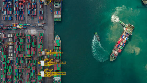
In today’s globalized world shipping goods all over the world is a common business. However, it is not always easy to keep track of where one´s shipment is and when it will arrive. This can be especially difficult when shipping a large number of items or shipping internationally.
A ship position can be determined by a variety of methods, including satellite tracking, radar tracking and AIS tracking. To ease down this process without the need of sophisticated equipment developers devise software for their clients on the basis of a reliable vessel traffic information tool.

AIS tracking is the most common method for determining a ship’s position. AIS stands for Automatic Identification System, and it allows ships to automatically transmit their position, course, and other data to other ships and shore-based stations. It`s integrated in Vessel Traffic Information API and furnishes accurate location data which will allow to track position and navigation in real time. Also, AIS data can be used by mariners to plan routes and avoid collisions, and besides data can be used by researchers to study maritime traffic patterns.
Vessel Traffic Information API is an automated service to track ship positions around the world in real time. In addition, it`s very easy to use, easily integrates in any systems and applications, and furnishes information in no time, with accuracy and reliability.
The software provides information on position that includes: area, current port, latitude and longitude, navigational status, speed, course and AIS source. Likewise the output will include departure port and ATD, call sign, current draught, course and speed and arrival port. It also supplies vessel name, type, flag, gross tonnage, summer deadweight, length overall, beam and year of built.
Vessel Traffic Information API gives data about all globally live on board vessels or by the range of area. It`s possible to see the list of all globally live on board vessels or by range of area.
How To Track Ship Positions With This API
The process is highly easy with Vessel Traffic Information API. By just selecting one of the three endpoints in the API, and inserting the IMO code of the vessel to track down, the API reports all the details. It also supports the possibility of searching on various vessels at the same time.
There are many advantages to using an API to track ships and shipments. First, to save time and money; then to track vessels automatically and at no cost. Second, its coverage has no limits, in all oceans and all riverways. Finally, it allows to plan routes and headings before hand to prevent issues that can affect the vessels, the cargo and the crew.
Stay ahead of competitors and optimize profits by planning, which is the key to success. Whether running a shipping company, an insurance business, a maritime organization, or whichever activity concerned about traffic by sea, this API is the right tool to save time and effort, and to optimize earnings.
How To Get Started
Once you count on a subscription on Zyla API Hub marketplace, just start using, connecting and managing APIs. Subscribe to Vessel Traffic Information API by simply clicking on the button “Start Free Trial”. Then meet the needed endpoint and simply provide the search reference. Make the API call by pressing the button “test endpoint” and see the results on display. The AI will process and retrieve an accurate report using this data.
Vessel Traffic Information API examines the input and processes the request using the resources available (AI and ML). In no time at all the application will retrieve an accurate response.
Choose an endpoint in the API (GET VESSEL DATA BY IMO CODE, GET CURRENT ROUTE BY IMO CODE or GET POSITION) and then input the IMO code of the vessel; the software will output a full report with all the necessary information. In this case the endpoint is Get Position and the vessel is 9251183. The response will look like this:
{
"status": 200,
"success": true,
"message": "IMO Code 9251183 is valid",
"data": {
"position_received": "2023-05-29 17:43 LT (UTC +2)1 minute ago",
"vessel_local_time": "2023-05-29 17:43 LT (UTC +2)",
"area": "BSEA - Black Sea",
"current_port": "-",
"latitude_longitude": "45.06955° / 29.8285°",
"navigational_status": "At Anchor",
"speed_course": "0.1 kn / -",
"ais_source": "Sulina (operated by DMG)"
}
}