Those people who are responsible for maritime security and operations, whether private or official organizations, need tools that allow to track down information about vessels in the world.
Developers are concerned about devising software for those clients so that they can find an easy way to gather data about ships globally, and a vessel traffic information application is a good basis.
Vessel Traffic Information API is the tool for developers as a starting point to develop software for their clients so as to enhance maritime security and operations. The tool provides information on vessels such as their location (area, current port, latitude and longitude, navigational status, course and AIS source), speed so as to estimate time of arrival at the following port or at its destination, as well as features of the vessel (name, type, flag, gross tonnage, summer deadweight, length, beam and year of built), and many other sensible data that allow to keep a vessel or a fleet under control for more efficient transportation.
All this information furnished by the API is useful for marine operations such as search and rescue, anti-piracy, and pollution response. It can also be used to track the movement of vessels throughout the world and to monitor vessel traffic in ports, detect illegal fishing, and monitor vessel traffic in protected areas.
Maritime companies can use Vessel Traffic Information API to track the movement of vessels in real-time. This is useful to improve maritime security, optimize fleet operations, and plan future vessel movements. Likewise it allows to study maritime traffic patterns, track vessel movements over time, and monitor vessel compliance with maritime regulations.
This data is useful for maritime security and operation teams who need to know the location of their vessels at all times.
The API makes marine operations more efficient. It´s powered by an information system that collects data from ships and transmits it to land-based stations. The data is then processed and made available to users such as port authorities and shipping companies. It can also include information about weather conditions and other ships in the area.
The application integrates Vessel AIS data into any system, which enhances real-time situational awareness, Track & Trace or monitor vessel performance, and provides IMO, MMSI, flag, name, length, width, type, call sign, ETA, destination and last known position of any ship in the world.
Vessel Traffic Information API furnishes information about all globally live on board vessels or by the range of area, the respective list, as well as individual ship detail info.
How Does It Work?
Counting on a subscription on Zyla API Hub marketplace, just start using, connecting and managing APIs. Subscribe to Vessel Traffic Information API by simply clicking on the button “Start Free Trial”. Then meet the needed endpoint and simply provide the search reference. Make the API call by pressing the button “test endpoint” and see the results on display. The AI will process and retrieve an accurate report using this data.
Vessel Traffic Information API examines the input and processes the request using the resources available (AI and ML). In no time at all the application will retrieve an accurate response.
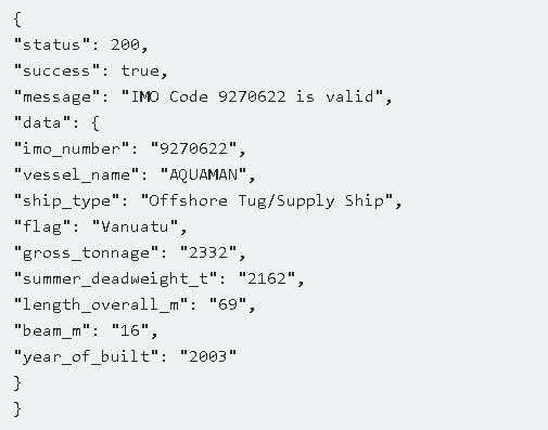
By choosing an endpoint in the API (GET VESSEL DATA BY IMO CODE, GET CURRENT ROUTE BY IMO CODE or GET POSITION) and then inputting the identification number of the vessel, the software will output a full report with all the necessary information. In this case the endpoint is Get Vessel Data By IMO Code and the vessel is 9270622. The response will look like this: